Sunday, May 23, 2010

Sea of Clouds


What a view! The sun rising over a sea of clouds, some rocks and trees in the foreground. The way the sunlight reflects off the clouds and the trees. Truly beautiful.

This card reached me from Taiwan. It shows the view of Mount Ali, or Alishan in Chiayi County. Alishan is a major landmark and tourist destination in Taiwan and it has become famous for its high mountain tea and wasabi production. In 2001 the area was declared a national scenic area. The Alishan mountain range has an average altitude of 2500 meters. Until the 1970s the logging industry was prominent in the area. The Alishan Forest Railway is a reminder of the early logging days, when narrow-gauge railways facilitated the transport. Today the Alishan highway, built in the 1980s, is the primary means of transport for tourists. They can visit the villages and temples within the Alishan National Scenic Area, and enjoy mountain wilderness along the hiking trails, and most of all the beautiful views from Mount Ali.

Thursday, January 21, 2010

L’Hemisfèric


This incredible building can be found in València, Spain. It is part of the futuristic museum complex of the City of Arts and Sciences. It includes an arts center, a science museum, an oceanographic park, and the Hemisfèric, which is an IMAX cinema and planetarium. It was designed by the local architect Santiago Calatrava. L’Hemisfèric was opened in 1998 as Europe’s largest planetarium with a dome diameter of 24 meters. The structure is built to resemble an eye – using the reflection on the water. At night, the eyelids are closed.

Wednesday, January 13, 2010

Wat Arun – The Temple of Dawn


Since I received this card today, I will move on, through the gulf of Thailand to Bangkok, the capital city of Thailand. The card shows an amazing sunset view of Wat Arun, the Temple of Dawn, from across the Chao Phraya River.

The full name of the temple is Wat Arunratchawararam Ratchaworamahawihan. Wat is the Thai word for a Buddhist temple. Wat Arun is named after Aruna, the Indian God of Dawn. It may have been given that name because the first morning light reflects off the surface of the temple. But the most spectacular views can be seen in the evening from across the river, when the sun sets behind Wat Arun and the towers make a prominent silhouette against the sky.

The most outstanding feature of the temple is the central prang, which is a Khmer-style tower. It is approximately 80 meters high and symbolizes Mount Meru, the center of the world in Buddhist cosmology. It is surrounded by four smaller prangs that hold statues of Phra Phai, the God of Wind. The structure is decorated with sea shells and pieces of porcelain, which had been used as ballast on ships sailing to Bangkok from China. It is possible to walk up the steep stairs of the main prang to two terraces that offer a lovely view of the river.

Tuesday, January 12, 2010

National Symbols of Singapore


This card reached me last October from Singapore. It shows two national symbols of the city state, which consists of several islands and is bordered by Malaysia to the North and Indonesia to the South. The city of Singapore is situated on the main island, which is connected to the Malaysian main land by two bridges.

The Merlion was designed by Fraser Brunner in 1964, one year before Singapore gained its independence, as a symbol for the Singapore Tourism Board. The artist Lim Nang Seng created the 8.6 m tall statue with a lion head and a fish tail in 1972. According to legend, prince Sang Nila Utama stranded on the island and saw an animal he thought to be a lion. Consequently he called the city “Singapura”, meaning lion city. The fish body represents the old name of the settlement, Temasek, meaning sea town, thus remembering the origin of the city as a fishing village. The cement statue and its 2 m tall cub were originally placed at the mouth of the Singapore River. In 2002 it was relocated 120 meters to a newly built park after a new bridge had blocked its view from the waterfront.

The Vanda Miss Joaquim became Singapore’s national flower in 1981. The hybrid between the Vanda teres and the Vanda hookerana was first discovered in 1893 by Miss Agnes Joaquim. It was picked as a national symbol from 40 other flowers for its qualities that were thought to best represent the nation. The orchid is known for its resilience, which reflect Singapore’s quest for progress and excellence. As a hybrid it is also a symbol for the multi-cultural heritage of the country.

Sunday, January 10, 2010

Dutch Windmills


For now, let’s stay in the Netherlands and just move a little along to the northwest. I received this card from a girl living in the province of Fryslân. In early January it’s cold and snowy there, and there’s probably a cold breeze coming in from the sea. Accordingly, the card shows a winter scenery with windmills covered in snow. Windmills are a typical sight for the Netherlands. Most windmills were built between the 15th and 18th centuries. There used to be 10.000 of them. Today, there are still more than 1000 windmills left. Some of them were made into museums, some were converted into living quarters. But while most of them are still ready-to-operate, the initial functions have long been taken over by newer technologies. Windmills were used to grind grain, saw wood, make oil or even paper. But most of the windmills in the Netherlands had been built for a different purpose. Large areas of the country lie below sea level – hence the name Netherlands. Windmills were used to pump water from the low lying areas. In that way new land was gained from the sea to be settled and cultivated. For a long time the windmills shaped the life of the people and the face of the country. Until today they remain a common sight in the Netherlands, especially in the coastal areas.

Sunday, January 3, 2010

Hunebedden in Drenthe


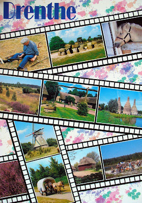
My first postcard of 2010 leads me across the western border of Germany to Drenthe, a province situated in the northeast of the Netherlands. It was sent on its way in the old year, and arrived in my letterbox on January 2nd. A beautiful collage of pictures shows the rural character of the area: moor land dominated by heath, old farmhouses with thatched roofs, a farmer with wooden shoes sharpening the blade of his scythe. While these impressions already prepare for a journey back in time, there is one picture that points to an even older cultural heritage: a megalithic grave. This is one of 54 Hunebedden, as they are called in Dutch, that still remain in the Netherlands. 52 of those can be found in Drenthe. The one pictured on my postcard is the southernmost, found near Havelte. The earliest farmers who settled the area belong to the Funnel Beaker Culture, so called because of the earthenware they produced. Around 3450 BC they started to build their burial sites out of huge boulders. These had made their way from Scandinavia about 200,000 years ago and were transported to the Netherlands by glaciers.